“De qué país?” What country are you from?
The question was shouted down by a man relaxing on a rock just above the trail.
He was probably an arriero, a donkey wrangler, or a campesino, a countryside farmer, supervising a herd of sheep or cows.
“Los Estados Unidos,” The United States, we replied.
“Trekking?” he asked.
“No, estamos corriendo,” we said. We are running.
“Corriendo?!,” he repeated, obviously shocked and amused. He started laughing and shook his head as if to say, now I’ve heard it all. “Los corredores americanos?!”
“Sí,” we started laughing with him. “Somos los corredores americanos!” We are the American runners.
The Cordillera Huayhuash is a north-to-south, glaciated, stunning mountain range in the Peruvian Andes. Although it is only 19 miles long, it contains some of the highest peaks in the country, including Yerupaja and 20,814-foot Siula Grande, made famous by English climber Joe Simpson in “Touching the Void.”

Carhuacocha
The Huayhuash Circuit is a roughly 85-mile route that circumnavigates the range. The trail passes through expansive pampas, past turquoise lakes, waterfalls and pre-Incan ruins, beneath glaciers and over 11 high alpine passes. Backpackers usually take 10 to 14 days to complete the route. With the help of a team of burros and arrieros to carry our camping equipment and food, los corredores americanos ran it in just six.
“As trail runners, we typically want to carry less, go farther and see more,” said Ridgway-based guide and owner of Highline Running Adventures, Jared Vilhauer. “…We can run in these mountains with little to nothing on our backs and cover twice as much terrain as the normal hiker. There is an incredible sense of freedom that comes along with moving through these types of places in this style.”

Vilhauer, who also takes clients hiking and running in Colorado’s San Juans, first visited the Cordillera Huayhuash in 2007. After talking with trekkers who completed the entire loop, he knew he had to experience the whole thing for himself. He returned to the Huayhuash in 2014 and being both pressed for time (his flight back to the U.S. was in three days) and an ultra runner (Vilhauer has completed several 50-mile races and will try for a 100-miler this fall) he decided to pack a light backpack and tackle the loop in two days.
“The trail was difficult to say the least, but after finishing the route, I knew I had to figure out a way to offer this trip to others so that they could experience it the way I had: fast and light around one of the most beautiful and remote mountain ranges in the Andes.”
So in June, a group of six American trail runners (and one Peruvian) set out from the tiny town of Llamac with Vilhauer as the guide to run around the Cordillera Huayhuash. Along for the adventure were: Vilhauer’s girlfriend, Amber King of Ridgway; myself (Heather Sackett, the author of this story) and Michael Contillo, of Telluride; Josh Nichols, of Colorado Springs; and Ray Sena, of the San Francisco Bay Area. It was Vilhauer’s first time organizing and guiding the trip. Joining him as a second guide was Lima-based runner Domingo Townsend.
We had planned on camping just outside of Llamac the night before our departure, but Pablo, our head arriero and cocinero (cook), generously invited us to stay in his family’s house. We set out early on the morning of the first day in an attempt to beat the heat. Although it’s winter in Peru, it also is their dry season, which means warm, sunny, dusty days and clear, cold nights. This stable weather pattern, known as the “Andean Summer,” is nearly perfect for running.

Punta Llamac
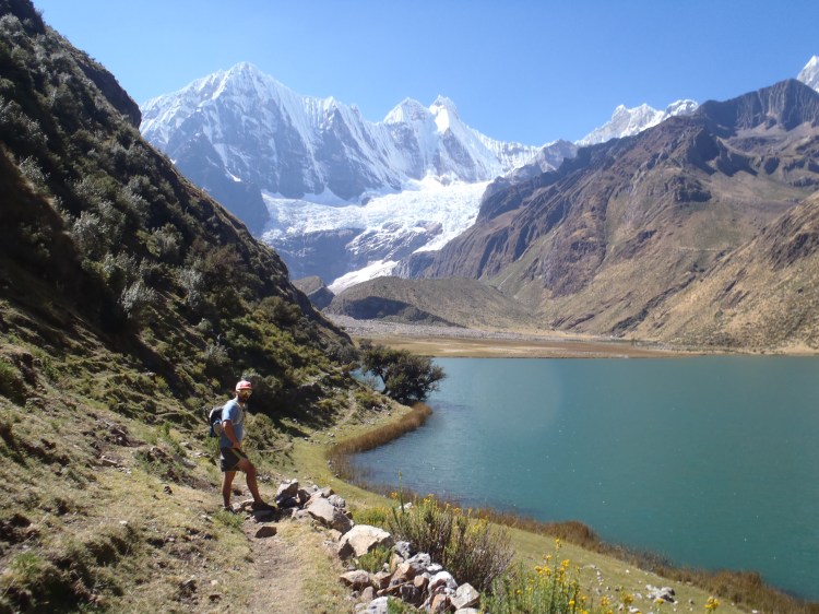
After asking the mountain gods, the apus, to keep us safe on our journey, we headed up switchbacks to the first pass. At Punta Llamac at 4,272 meters — more than 14,000 feet — we earned our first real glimpse of the snow-covered peaks. The trail then hugs the mountainside in a long traverse and descends down to the valley floor where it winds through grazing cows and the stone huts of shepherds.
In this valley lies Laguna Jahuacocha, a high alpine lake where most trekkers spend their first night and where we would eventually spend our last night on the Huayhuash, five days later. But for now we left the lake in the rearview and continued up to the twin passes of Sambuya Punta and Rondoy Punta at about 15,500 feet.
From here we could make out the bright orange specks of our tents in the valley campsite at Matacancha far below. Our team of burros, horses and arrieros had taken an easier route along a dirt road and were waiting at camp with snacks and tea when we met up with them after 17 miles of running and hiking. Since Matacancha can be accessed by a dirt road, this is where many trekkers begin the Huayhuash circuit.

En route to the campsite at Matacancha
Day two began with a lesson in animal husbandry. All along the circuit, the campsites were well-utilized by other groups of hikers, many of which had also hired teams of guides and burros. Horses were usually hobbled overnight, with their front feet tied together. It meant they could wander about the meadow to graze, but couldn’t stray very far. Donkeys, on the other hand, were left to roam free. Several mornings began with the shouts of arrieros frantically running around the campsite and scaling the surrounding hills, rounding up their wayward burros.

Los burros
The trail started with a steep but short climb to the northern-most point on the circuit, Cacananpunta. Giant condors soared overhead, riding the thermal updrafts. We then descended through a rolling valley until we came to a gate where two campesinos were stationed. At several points along the Huayhuash, hikers have to pay a small entrance free to the communities located along the route. This is for use of the campsites, all of which have bathroom facilities, and for the burros and horses to graze on the land. We paid 40 soles, or about $13, apiece at the entrance to the Jirishanca region.

Josh paying $40 soles at Jirishanca
One more gradual climb up to Carhuac Pass and then the trail rolled downhill through farmland where we found a pile of cow’s teeth, which represented buena suerte, good luck, Townsend said. We left them lined up on a rock next to the trail for the next runners in our group to admire and continued down to the campsite at Carhuacocha.

Dientes de las vacas
Situated on top of a glacial moraine above an alpine lake and at the foot of some of the tallest peaks in Peru, Carhuacocha is a spectacularly beautiful campsite.
“It is really hard to describe why to people who have not been there and until you actually stand at Laguna Carhuacocha or one of the many high passes and stare up at the towering peaks above, you probably wouldn’t understand,” Vilhauer said. “The scenery and terrain are constantly changing and often surreal…”
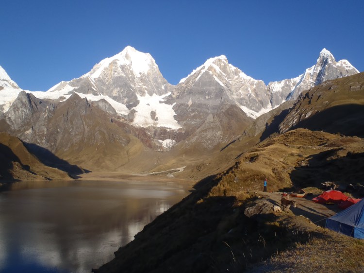
Campsite at Carhuacocha
While at this campsite, we got a taste of that surreal experience Vilhauer mentioned. We heard a crack and a roar and looked up to see the glaciers of Yerupaja calving. Huge chunks of ice broke off and tumbled down the mountain, creating a snowy plume that billowed up all around the sheer face. The mountains were more than a mile away, but the sound was still deafening and its echo filled in the valley.
Calving glaciers on Yerupaja
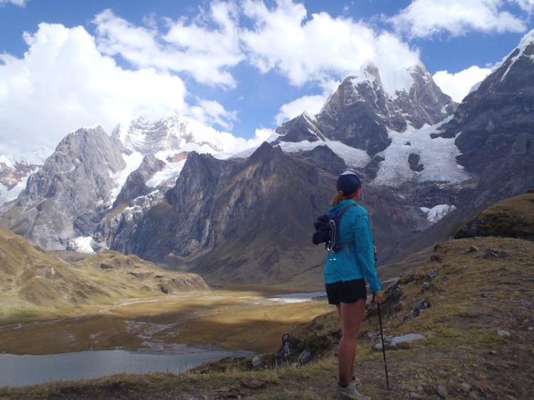
Day three along the eastern edge of the range proved to be one of the longest and most mentally challenging days on the circuit. The day started out by passing three turquoise lakes and a climb up to Siula Punta at 15,800 feet. Then came a descent into rolling farmland and another climb to Portochuelo de Huayhuash. Although this was a gradual climb to 15,700, some runners started to feel the effects of the altitude. Dizziness, headaches and nausea crept in and the only food that sounded appetizing was M&Ms and Snickers bars. During this second climb of the day was also when the skies dumped a little bit of snow, rain and graupel on us, the only precipitation during the trip.
After a long descent down to Lake Viconga, we rewarded our sore muscles and tired spirits with a soak in the Viconga Hot Springs. The three steaming pools of varying temperatures are at 14,250 feet and feature campesinos selling Cokes, beer and snacks out of a small building.
On day four we crossed the highest pass of the trip: Punta Cuyoc at 16,400 feet. After a steep descent off the pass, the terrain turned mellow and rolling as we made our way down the sleepy river valley of Quebrada Huanacpatay. Some members of the group broke off the main trail and headed on a side trip up San Antonio Pass. At 16,500, the pass offered sweeping 360-degree views of the west face of Siula Grande, the Cordillera Raura to the south and the open, grassy meadows below. The trail continued down valley to the tiny community of Huayllapa, where we spent the night at a small boarding house.
We set out from Huayllapa the next morning with two more runners: the dogs that had been following our group on and off all trip. In the Peruvian countryside, dogs are used to herd and guard livestock. They are not usually friendly to strangers and can be downright aggressive. In the towns, they are seen more as communal property than pets and the stray street dogs are loyal to whoever will feed and pet them. Being Americans, we did both and ended up with two dog friends who “protected” us from the arrieros (who generally thought of the dogs as a nuisance) and other campers who came between us and them.
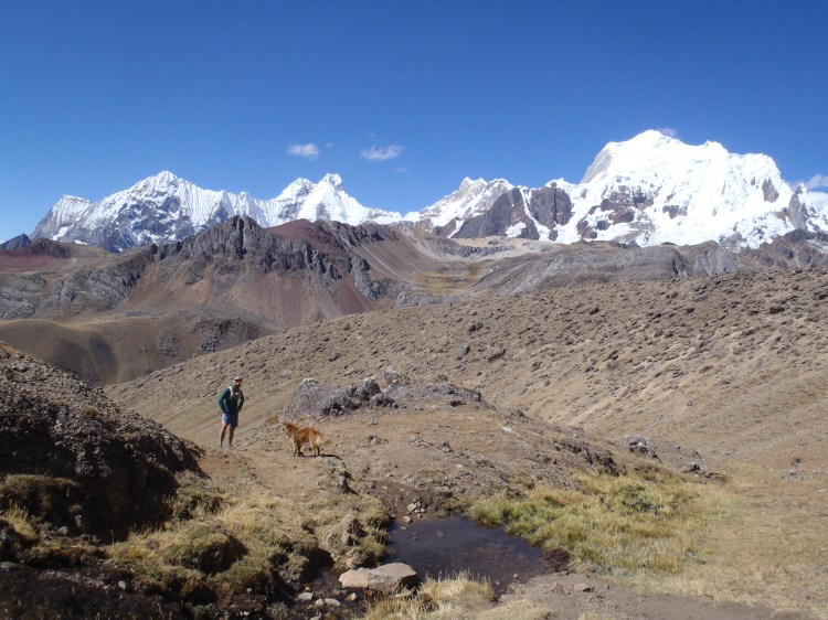
New dog friend
Day five started with a six-mile climb out of town to the first pass of the day, Tapush Punta. The trail then meandered through idyllic alpine meadows where campesinos wearing traditional, colorful Quechua clothing sat by the river while singing a tune and knitting. At the second pass of the day, we were elated to find a message from our friends, the faster runners of the group, who had come through about an hour earlier. “Gappa x2” was etched into the dirt at the top of Yaucha Punta. It was a Boston-accented joke that referred to the second and final “gap” or pass of the day. It was all downhill from here. After a few miles through cow pastures and dusty trails, we were back at Jahuacocha, the lakeside campsite we passed through on the first day of our adventure and where we would spend our last night on the Huayhuash.
Dinner the last night was a popular Peruvian delicacy called Aji de Gallina, a spicy chicken stew served with hard-boiled eggs over rice and potatoes. Pablo and his sister Sonia had been preparing similar dishes all week, but saved this as a final-night feast. The route on day six involved just seven miles of mostly downhill backtracking on the trail we came in on, returning to the town of Llamac. We were tired and dirty but happy. Sore, but safe and sound. We were los corridores americanos.
