Category Archives: Uncategorized
The Best Crested Butte Hikes
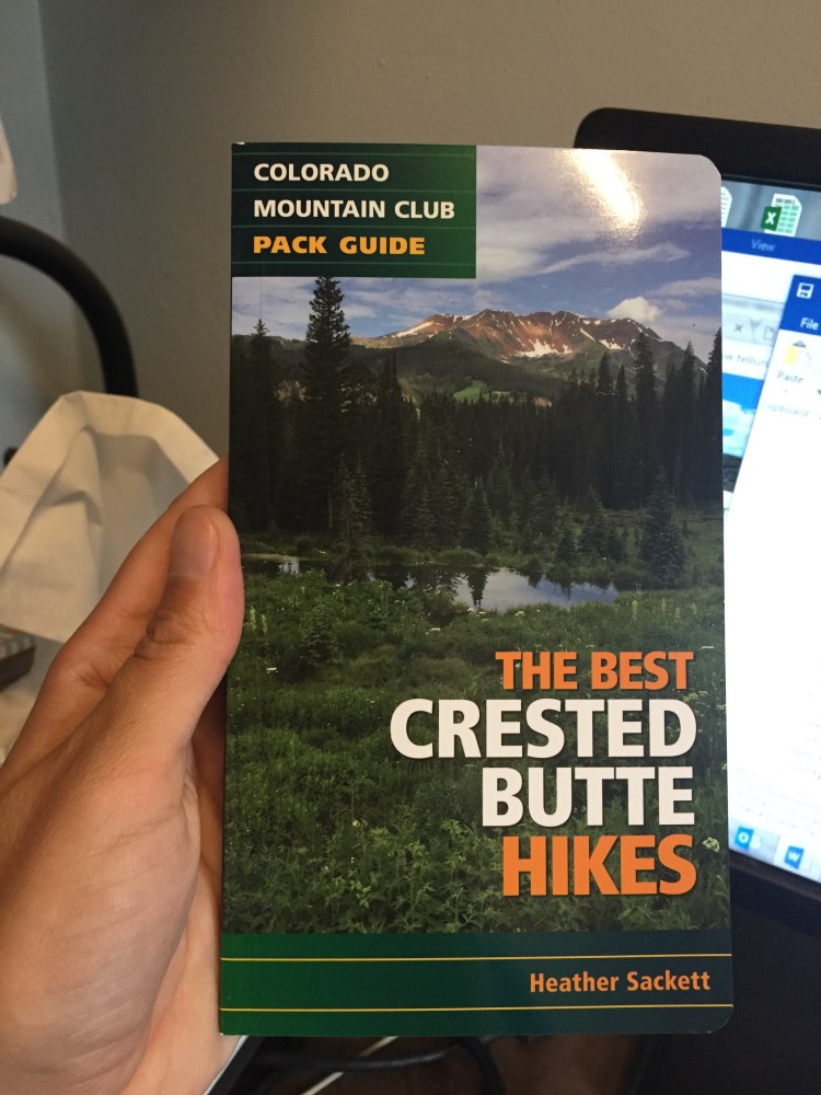
I spent last summer traipsing around Crested Butte researching this and taking photos. It’s finally out and available on Amazon! Thanks to everyone who helped.
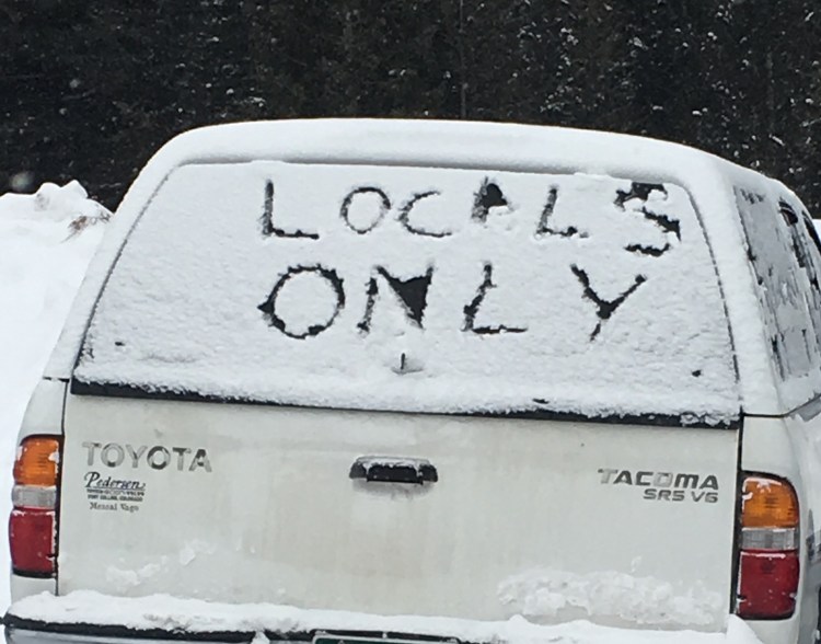
How localism is ruining backcountry skiing
Somewhere near Telluride, Colorado is a super-top-secret valley. You can find it on maps, but if you attempt to make the trek there, you might not be so lucky. The highway sign pointing the way has disappeared so many times the department of transportation gave up replacing it. Lost drivers are pointed the wrong way and given directions out of town. Unsuspecting posters to social media are scolded for hash-tagging the name of the town in photos. Some inhabitants of this unnamed valley don’t want the outside world to know it exists. It’s The Valley That Must Not Be Named.
This Shangri-La does not have a single store or restaurant or paved roads. It’s the middle of nowhere. But with a bunch of other people and houses and dogs roaming free. “Settlement” is a better description, although it technically has a mayor and town manager.
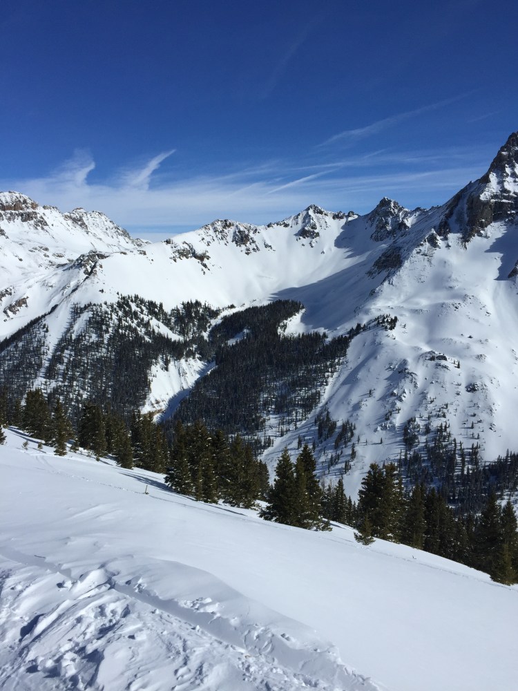
It also has epic backcountry skiing. And certain skiers go to great lengths to keep it a mystery valley because if you can’t find it, you can’t ski it.
Two beautiful canyons are easily accessed from town and provide sweeping views of the high alpine, gnarly couloirs, perfectly pitched tree runs, all often covered in plenty of powder. If you have trouble finding fresh turns in this vast valley, it’s due to extreme laziness or lack of creativity. It is the antithesis of the Disneyland that is the nearby ski resort of Telluride. Peace and solitude reign.
Skiers have been protective of their powder stashes since the day they first strapped long wooden planks to their feet. Powder is a finite resource and when this valley is good, it is gooooooood. But the attitude of some valley skiers goes too far. It is an attitude of hyper localism.
Localism has long been rampant in surf culture and is now spilling over into the valley’s backcountry skiing. Parking wars have become frequent. Passive aggressive notes are being left on vehicles. Would-be backcountry skiers who reside one or two towns over are made to feel like unwelcome outsiders. Acting like the self-appointed steeze police, a few local skiers try to determine who has the street cred to ski there and who does not. To be fair, not all the skiers of the valley have this attitude; some longtime residents are embarrassed by their neighbors’ actions. But the ones that do have this attitude are ruining it for everyone.
In a world where resort skiing is increasingly a sport reserved for the rich, backcountry skiing is the great egalitarian equalizer. Freed from the tyranny of expensive lift tickets, touring requires little more than the will to go uphill. That is the main reason residents of The Valley That Must Not Be Named need not worry about their ski runs getting discovered and tracked out: Most people are just too lazy to do the required 3,000-feet-plus vertical on an icy skin track. The valley and its people are nothing if not hardcore.
But there is another reason the harassment of visiting backcountry skiers needs to stop. In a time when our country’s administration is seeking to alienate and exclude certain sectors, this animosity toward fellow skiers smacks of nativism: the policy of protecting the interests of established inhabitants against those of immigrants.
This attitude of I-found-it-first-now-I’m-closing-the-door-behind-me is a shame, because one of the joys of recreating in wild places is sharing them with others. Getting there first doesn’t mean you can hoard the outdoors for yourself. Let’s face it: Nearly all of us are transplants to these mountains and few of us have been here in this tiny southwest corner of the state longer than a generation. Being a “local” does not give anyone the right to intimidate others who are simply enjoying the very same thing they share a passion for.

Localism goes against the backcountry spirit of camaraderie, friendship, and community. The love of skiing should unite, not divide. It shouldn’t be cliquey; it should be inclusive. It is not a place for barriers. Skiers should be free to bring their friends to their favorite ski runs without the fear of being heckled and hassled.
Most important, these mountains are public lands open to and owned by everyone. If you are willing and able to earn your turns, you have just as much right to be there as anyone, with or without proof of residency.
The ranks of those initiated in beacon checks, kick turns on skin tracks, face shots, high-fives on ridgelines and celebratory after-beers in the parking lot always has room for more members. The skiers of The Valley That Must Not Be Named should hope that they don’t succeed in scaring off their backcountry brethren. Because after all the effort to make sure they are the only ones out there, they might just find out it’s lonely at the top.

This essay appeared in Adventure Journal on Feb. 22, 2017.
Did you go to the top?
“Are you going all the way to the top?” The question rang out from a ponytailed, shorts-and-T-shirt-clad tourist who was on his way down. It was a common question. And it is one that always annoys me because it doesn’t make any sense. On so many hikes and trail runs, there is no “top.”
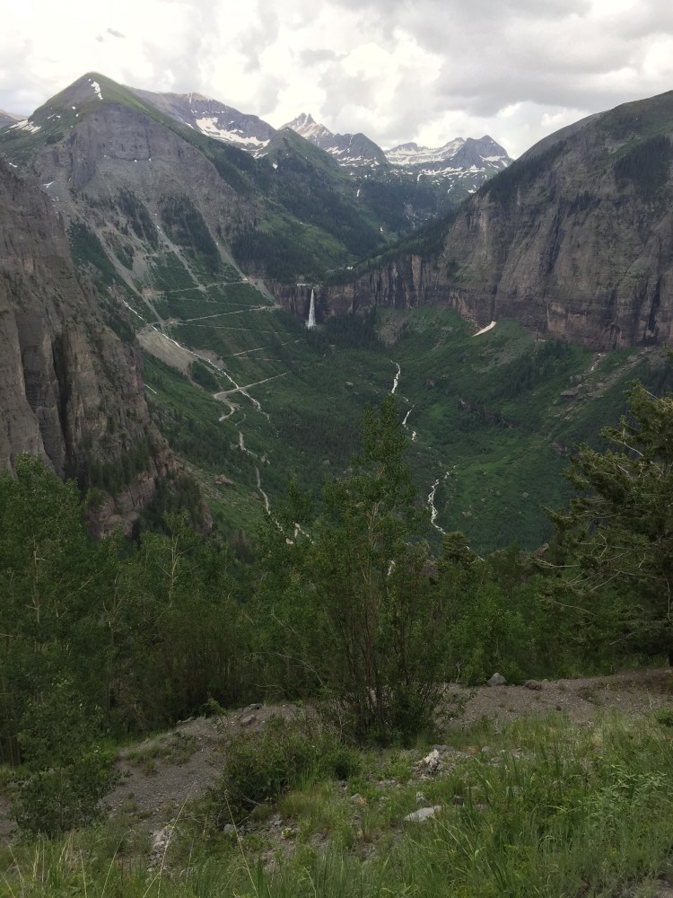
We were trekking into Bridal Veil Basin, a lofty and rugged wilderness above Telluride. There are towering rock spires, babbling brooks to rock-hop across, lingering pockets of snow, the twisted metal of mining ruins, ridgelines, saddles and sweeping vistas. But there is no top. No summit to speak of.
We began the day not with a drive to the top of Bridal Veil Road, but from our home in town. Wanting to be purists, nothing would do but door-to-door on foot. So we ran the two miles on the River Trail to the end of the canyon, climbed two more up the switchbacks to the power station perched on the edge of a cliff near the falls, through the gate and into the basin.
We were on our way to the neighboring mining town of Silverton. Our packs were light and all we carried was food, water and a change of socks and underwear. “Credit card camping” we called it.
The skies threatened rain, but the verdant hillsides were covered with an array of blue columbines, orange paintbrushes and yellow mules ears. The trail petered out at one point and we found ourselves on the wrong side of a rock outcropping. No matter. We tramped through the alpine meadow until we found the trail again. With the terrain so open and expansive, it was impossible to get lost because you could see where you needed to go.
We took a left at an unmarked trail junction and climbed to the ruins of the Lewis Mill. The five-story looming wooden structure was a state-of-the-art ore concentration mill when it was built in 1910. Now the restored building attracted hikers to gape at the absurdity of an industrial behemoth in the middle of a backcountry basin. We took a minute to wander among the rusty ruins and then continued up to Lewis Lake and Columbine Pass at 13,058 feet.

We admired the cerulean waters of Columbine Lake and started down the other side on a long, rolling downhill. The trail traversed around the basin and through thick spruce forests before dumping us out on Ophir Pass Road. We took the dirt road to its junction with U.S. 550, crossed the highway and searched through the underbrush until we found a little-used trail that parallels the road and would take us the final three miles into Silverton.
After a few drinks and snacks at the rum bar, we checked into the historic Grand Imperial Hotel, showered and made plans to head down to the hotel’s restaurant for a proper dinner. But, exhausted after our roughly 27-mile run, we fell asleep instead.
* * *
“You have to smile more,” I said. “Look friendly, like we aren’t murderers.” I plastered a big, shit-eating grin on my face as I stuck out my thumb. It was 8 a.m. and we stood on the shoulder of the highway, just outside of Silverton. We had decided to cut out a few miles of potentially dangerous highway running and catch a ride to the top of Red Mountain Pass and come back to Telluride via Black Bear Pass. Our grinning worked. The next car pulled over.
It was a sedan loaded down with camping equipment in the back seat and two college-aged girls in the front. They were headed to Mineral Creek campground about two miles up the road. Not far enough. We thanked them and watched them drive away.
From the gas station across the street a man with a grey beard and an old, blue pick-up truck motioned us over to him. He was headed to Ouray and could drop us at the pass if we didn’t mind cramming into the front on the bench seat. We clambered in. As we drove off, the cab filled with the smell of stale beer. I looked at the floor, expecting to see empty cans rattling around.
“So what were you doing in Silverton?” Mike asked the man. He told us he was a miner (a real live miner!) at the newly re-opened Camp Bird Mine and came to Silverton for the night “to do some drinking,” thereby solving the mystery of the alcohol smell. At least he was honest. Worried we were now riding with a still-drunk driver, I searched for a seat belt. No such luck. But it didn’t matter. Our driver ferried us the eight or so miles to the top of the pass with ease, rounding each corner slowly and smoothly on a road he had probably driven thousands of times.
We hopped out at the pass, thanking the miner for the ride. We briefly wondered if we should have given him some money for his trouble, but decided that paying is not in keeping with the spirit of hitch-hiking. It’s about good karma and doing a favor for a stranger. We resolved to pay it forward as soon as we could.
The pass road was windy and Jeeps, laden with passengers, passed us every few minutes, kicking up dust that swirled around us. One Jeep pulled over and rolled down its window.
“You guys are so impressive!” a tourist called out. “Thanks…?” we muttered and kept walking. “Are you going all the way to the top?” they asked. Mike and I exchanged glances. That question again. “Telluride,” we said, in unison.
If they are impressed by something as simple as people walking, using our legs as a means of transportation, they must lead pretty boring lives, I thought to myself. I didn’t feel flattered that they thought we were hardcore. I felt annoyed that trekking the same old, rocky mining roads that people, mules and horses walked a century ago was now viewed as exotic and extreme by lazy tourists. I felt like a spectacle. They drove off and we continued climbing up the pass.
It was even more windy as we started down Black Bear Pass. The one-way road snaked down across Ingram Basin, past mining trestles and tailings piles. We had just passed the infamous, rocky and steep “Steps” section of the pass and Ingram Falls when we spotted a green Jeep down off the side of the road, nestled among the boulders. Its windshield was smashed and it was facing back up the slope, as if it had rolled once and came to a stop. “Wow”, I said under my breath. We learned later the occupants were uninjured and the Jeep was towed out the next day.
We continued the last few easy miles back to town and ran straight to our favorite main street restaurant for burgers and margaritas. We overheard the foursome at the table next to us talking about the Jeep accident on Black Bear Pass and realized it was the same people we saw earlier who were so impressed by us. I tried to turn away, but it was too late. They recognized us.
“Hey!” they called. “You were the two we saw running the pass! I guess you made it to the top. Can we take your picture?!”
We relented and mugged for the camera, feeling silly and self-conscious, sweaty and dirty.
We lingered at the outdoor table, watching people walk by, enjoying the warm sun, heads fuzzy from the margaritas. We had run and hiked roughly 40 miles to Silverton and back, through the remote and stunningly beautiful high alpine of the San Juan Mountains. We explored the remnants of the region’s mining history, which linked us with the past and our miner forbears.
It was the first time we had run those sections of trail and seen those blue alpine lakes. We had depended on the kindness of strangers. We learned things about each other. We had gotten a ton of exercise and spent the majority of two entire days outside. The number of hours spent playing in the mountains is always the benchmark by which I judge the success of a weekend. I felt languid and content in the sunshine. We had finally made it to the top.
Los Corredores Americanos
“De qué país?” What country are you from?
The question was shouted down by a man relaxing on a rock just above the trail.
He was probably an arriero, a donkey wrangler, or a campesino, a countryside farmer, supervising a herd of sheep or cows.
“Los Estados Unidos,” The United States, we replied.
“Trekking?” he asked.
“No, estamos corriendo,” we said. We are running.
“Corriendo?!,” he repeated, obviously shocked and amused. He started laughing and shook his head as if to say, now I’ve heard it all. “Los corredores americanos?!”
“Sí,” we started laughing with him. “Somos los corredores americanos!” We are the American runners.
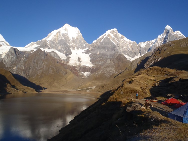
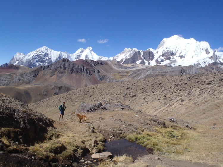
The Cordillera Huayhuash is a north-to-south, glaciated, stunning mountain range in the Peruvian Andes. Although it is only 19 miles long, it contains some of the highest peaks in the country, including Yerupaja and 20,814-foot Siula Grande, made famous by English climber Joe Simpson in “Touching the Void.”

Carhuacocha
The Huayhuash Circuit is a roughly 85-mile route that circumnavigates the range. The trail passes through expansive pampas, past turquoise lakes, waterfalls and pre-Incan ruins, beneath glaciers and over 11 high alpine passes. Backpackers usually take 10 to 14 days to complete the route. With the help of a team of burros and arrieros to carry our camping equipment and food, los corredores americanos ran it in just six.
“As trail runners, we typically want to carry less, go farther and see more,” said Ridgway-based guide and owner of Highline Running Adventures, Jared Vilhauer. “…We can run in these mountains with little to nothing on our backs and cover twice as much terrain as the normal hiker. There is an incredible sense of freedom that comes along with moving through these types of places in this style.”

Vilhauer, who also takes clients hiking and running in Colorado’s San Juans, first visited the Cordillera Huayhuash in 2007. After talking with trekkers who completed the entire loop, he knew he had to experience the whole thing for himself. He returned to the Huayhuash in 2014 and being both pressed for time (his flight back to the U.S. was in three days) and an ultra runner (Vilhauer has completed several 50-mile races and will try for a 100-miler this fall) he decided to pack a light backpack and tackle the loop in two days.
“The trail was difficult to say the least, but after finishing the route, I knew I had to figure out a way to offer this trip to others so that they could experience it the way I had: fast and light around one of the most beautiful and remote mountain ranges in the Andes.”
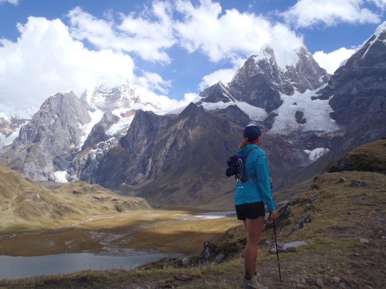
So in June, a group of six American trail runners (and one Peruvian) set out from the tiny town of Llamac with Vilhauer as the guide to run around the Cordillera Huayhuash. Along for the adventure were: Vilhauer’s girlfriend, Amber King of Ridgway; myself (Heather Sackett, the author of this story) and Michael Contillo, of Telluride; Josh Nichols, of Colorado Springs; and Ray Sena, of the San Francisco Bay Area. It was Vilhauer’s first time organizing and guiding the trip. Joining him as a second guide was Lima-based runner Domingo Townsend.
We had planned on camping just outside of Llamac the night before our departure, but Pablo, our head arriero and cocinero (cook), generously invited us to stay in his family’s house. We set out early on the morning of the first day in an attempt to beat the heat. Although it’s winter in Peru, it also is their dry season, which means warm, sunny, dusty days and clear, cold nights. This stable weather pattern, known as the “Andean Summer,” is nearly perfect for running.

Punta Llamac
After asking the mountain gods, the apus, to keep us safe on our journey, we headed up switchbacks to the first pass. At Punta Llamac at 4,272 meters — more than 14,000 feet — we earned our first real glimpse of the snow-covered peaks. The trail then hugs the mountainside in a long traverse and descends down to the valley floor where it winds through grazing cows and the stone huts of shepherds.
In this valley lies Laguna Jahuacocha, a high alpine lake where most trekkers spend their first night and where we would eventually spend our last night on the Huayhuash, five days later. But for now we left the lake in the rearview and continued up to the twin passes of Sambuya Punta and Rondoy Punta at about 15,500 feet.
From here we could make out the bright orange specks of our tents in the valley campsite at Matacancha far below. Our team of burros, horses and arrieros had taken an easier route along a dirt road and were waiting at camp with snacks and tea when we met up with them after 17 miles of running and hiking. Since Matacancha can be accessed by a dirt road, this is where many trekkers begin the Huayhuash circuit.

En route to the campsite at Matacancha
Day two began with a lesson in animal husbandry. All along the circuit, the campsites were well-utilized by other groups of hikers, many of which had also hired teams of guides and burros. Horses were usually hobbled overnight, with their front feet tied together. It meant they could wander about the meadow to graze, but couldn’t stray very far. Donkeys, on the other hand, were left to roam free. Several mornings began with the shouts of arrieros frantically running around the campsite and scaling the surrounding hills, rounding up their wayward burros.

Los burros
The trail started with a steep but short climb to the northern-most point on the circuit, Cacananpunta. Giant condors soared overhead, riding the thermal updrafts. We then descended through a rolling valley until we came to a gate where two campesinos were stationed. At several points along the Huayhuash, hikers have to pay a small entrance free to the communities located along the route. This is for use of the campsites, all of which have bathroom facilities, and for the burros and horses to graze on the land. We paid 40 soles, or about $13, apiece at the entrance to the Jirishanca region.

Josh paying $40 soles at Jirishanca
One more gradual climb up to Carhuac Pass and then the trail rolled downhill through farmland where we found a pile of cow’s teeth, which represented buena suerte, good luck, Townsend said. We left them lined up on a rock next to the trail for the next runners in our group to admire and continued down to the campsite at Carhuacocha.

Dientes de las vacas
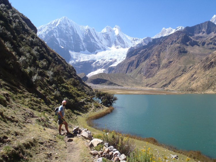
Situated on top of a glacial moraine above an alpine lake and at the foot of some of the tallest peaks in Peru, Carhuacocha is a spectacularly beautiful campsite.
“It is really hard to describe why to people who have not been there and until you actually stand at Laguna Carhuacocha or one of the many high passes and stare up at the towering peaks above, you probably wouldn’t understand,” Vilhauer said. “The scenery and terrain are constantly changing and often surreal…”
Campsite at Carhuacocha
While at this campsite, we got a taste of that surreal experience Vilhauer mentioned. We heard a crack and a roar and looked up to see the glaciers of Yerupaja calving. Huge chunks of ice broke off and tumbled down the mountain, creating a snowy plume that billowed up all around the sheer face. The mountains were more than a mile away, but the sound was still deafening and its echo filled in the valley.
Calving glaciers on Yerupaja
Day three along the eastern edge of the range proved to be one of the longest and most mentally challenging days on the circuit. The day started out by passing three turquoise lakes and a climb up to Siula Punta at 15,800 feet. Then came a descent into rolling farmland and another climb to Portochuelo de Huayhuash. Although this was a gradual climb to 15,700, some runners started to feel the effects of the altitude. Dizziness, headaches and nausea crept in and the only food that sounded appetizing was M&Ms and Snickers bars. During this second climb of the day was also when the skies dumped a little bit of snow, rain and graupel on us, the only precipitation during the trip.
After a long descent down to Lake Viconga, we rewarded our sore muscles and tired spirits with a soak in the Viconga Hot Springs. The three steaming pools of varying temperatures are at 14,250 feet and feature campesinos selling Cokes, beer and snacks out of a small building.
On day four we crossed the highest pass of the trip: Punta Cuyoc at 16,400 feet. After a steep descent off the pass, the terrain turned mellow and rolling as we made our way down the sleepy river valley of Quebrada Huanacpatay. Some members of the group broke off the main trail and headed on a side trip up San Antonio Pass. At 16,500, the pass offered sweeping 360-degree views of the west face of Siula Grande, the Cordillera Raura to the south and the open, grassy meadows below. The trail continued down valley to the tiny community of Huayllapa, where we spent the night at a small boarding house.
We set out from Huayllapa the next morning with two more runners: the dogs that had been following our group on and off all trip. In the Peruvian countryside, dogs are used to herd and guard livestock. They are not usually friendly to strangers and can be downright aggressive. In the towns, they are seen more as communal property than pets and the stray street dogs are loyal to whoever will feed and pet them. Being Americans, we did both and ended up with two dog friends who “protected” us from the arrieros (who generally thought of the dogs as a nuisance) and other campers who came between us and them.
New dog friend
Day five started with a six-mile climb out of town to the first pass of the day, Tapush Punta. The trail then meandered through idyllic alpine meadows where campesinos wearing traditional, colorful Quechua clothing sat by the river while singing a tune and knitting. At the second pass of the day, we were elated to find a message from our friends, the faster runners of the group, who had come through about an hour earlier. “Gappa x2” was etched into the dirt at the top of Yaucha Punta. It was a Boston-accented joke that referred to the second and final “gap” or pass of the day. It was all downhill from here. After a few miles through cow pastures and dusty trails, we were back at Jahuacocha, the lakeside campsite we passed through on the first day of our adventure and where we would spend our last night on the Huayhuash.
Dinner the last night was a popular Peruvian delicacy called Aji de Gallina, a spicy chicken stew served with hard-boiled eggs over rice and potatoes. Pablo and his sister Sonia had been preparing similar dishes all week, but saved this as a final-night feast. The route on day six involved just seven miles of mostly downhill backtracking on the trail we came in on, returning to the town of Llamac. We were tired and dirty but happy. Sore, but safe and sound. We were los corridores americanos.
Settling into the rhythm of a ski town’s off season
Sometime in April, a curious phenomenon occurs in ski towns across the American West.
The lifts stop spinning, curbing the flow of tourists and money. Closing day marks the end of employment for hundreds of workers. Lifties, restaurant servers, bus drivers, and ski instructors pack up Outbacks and Tacomas and hit the road, off to the desert, to Mexico, to beach adventures. With a two-week break from school, local families leave to visit relatives or someplace warm. Do the restaurants and businesses all close down because the people leave or do people leave because everything is shut tight?
Overnight, ski town turns to ghost town.
Spring elsewhere means green grass and flowers, gentle showers, mild temperatures, and pleasant sunshine. Call it off-season or mud-season, but what constitutes spring in the mountains is an epic battle between summer and winter, each attempting to claw the months of April and May into its grasp. Spring in the mountains means snowstorms, dust storms, wind storms, and perpetually moody and capricious skies. Spring in the mountains does not come on as a slow advancement. It’s two steps forward and one step back. It happens in violent fits and starts with sunny warm days made for main street bench-sitting juxtaposed with a foot of wet snow. Dust storms from the Southwest make it snow red dirt (“snirt”) from the skies. Trails above the valley are still buried under too much snow for biking or hiking. It’s no wonder everyone leaves.
Everyone except me.
It takes a few days to settle into the rhythm of off season, but soon something magical happens. Without the distractions of powder days and boozy nights, I embrace simplicity. There are no obligations, no plans, no pressure, no fear of missing out, nowhere to be. The thing to do is just enjoy being here.
Ironically, the one time of the year when huge snowstorms are practically guaranteed is after the resort closes for the season. But whether the lifts are shuttling passengers is irrelevant. If there’s fresh snow to be skied, we just skin for it. After months of skier and snowcat compaction, the resort slopes have somewhat lower avalanche danger than a true backcountry snowpack. Plus, they’re right out my front door.
Spring storms must be skied early because by midday any fluff has turned to cement. Dawn patrol it is. Nature has quickly reclaimed what was tame just a few weeks earlier so we carry beacons, shovels, probes and follow backcountry protocol, which feels strange in terrain I have memorized. The old adage that you appreciate something more when you work for it applies. Runs that became routine months ago when a lift dropped me at the top are thrilling again when I earn my turns and don’t have to share the trail with hundreds of others. An impossibility during the busy season, I get first tracks on my favorite pistes. There’s an immense satisfaction of devoting an entire day to just two top-to-bottom runs without the aid of machines.
Spring doesn’t have the flashiness of fall or the crisp air and sparkling snow of winter or the drama of summer thunderstorms and rainbows. Spring beauty is subtle. It’s dirty and dreary, verging on lonely. But I love it because it’s mine.
Fuzzy buds appear on trees. The snowpack in shady areas of my favorite trail slowly disappears, shrinking by a little bit each time I run it. The full moon seems brighter. Mud clings to shoes and tires. Bunnies and robins hop down sidewalks and dart under bushes. Elk, looking scraggly after a long winter, come down to lower elevations to graze on tender, new shoots of grass. Menacing clouds race across the horizon. On the first really warm day, the river rises with snowmelt and by midday is brown and churning with branches. By dark it is barely a trickle again as the snow up high refreezes.
Walking down a deserted main street a few days ago, we saw some friends on the other side of the street. They waved and called out, “Look, people!,” joking that the four of us were like the sole survivors of a zombie apocalypse. We met and hugged in the middle of the street because we could. We stood for a few minutes, taking in the soft, pink alpenglow that the sunset cast on the end of the box canyon, the very same alpenglow that happens every night and causes the on-season hoards to pull out their cell phone cameras. But on this April evening in the quiet solitude, it seemed even prettier than usual. Maybe it was because there was no one else around to see it.
*This essay appeared in Adventure Journal on 4/21/16
The art of skinning: A step-by-step guide
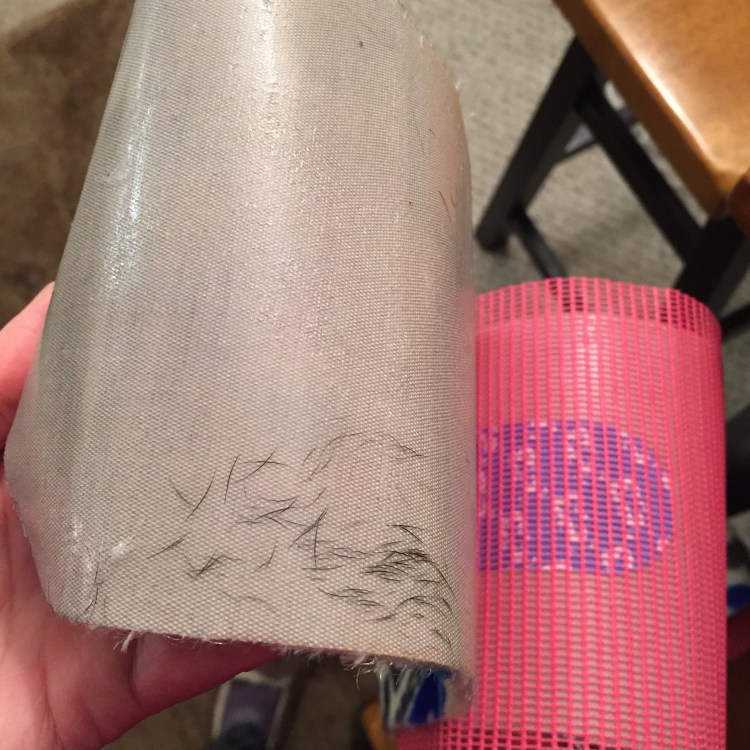
Avoid getting dog fur on the insanely sticky part of the skin that acts as a dog fur magnet. Dog fur, lint, hair, dust, will all reduce the stickiness of the skin. It’s obviously too late to prevent this.
Pull as hard as you can on the tail of the skin to clip it around the end of the ski (or in your case, the two “skis” of your splitboard). Realize spending $120 a month on CrossFit has had no effect on improving your grip strength. Give up. Ask boyfriend to complete this task.
Strap in and away you go!
Forget everything you’ve ever learned about cross-country skiing; those rules don’t apply. This is skinning. And it’s dumb.
Don’t bother digging in your edges; they won’t help you here. Instead, counterintuitively make sure as much surface area of the skin as possible is in constant contact with the snow. Trust the skin will hold you.
Don’t lean too far forward or you will fall on your face.
The skin track will invariably be too steep and icy. Curse the Ophirites who put it in.
When you come to a switchback, there are two ways of changing direction: one huge ski-ballet-like turn, which requires unhinging your joints to perform successfully or a bunch of really little tiny steps, slowly turning your body from 9 o’clock to 3 o’clock or from 3 o’clock to 9 o’clock. Neither of these methods work.
Fall off the skin track three or four times for no discernable reason.
Put your risers up on steep parts. This actually helps.
When you come to a tiny downhill section and remember you can’t actually ski, do a snowplow for life while leaning forward, knock-kneed, legs shaky and splayed like a newborn baby giraffe learning how to stand up. Realize you should have put those once-helpful risers down before skiing downhill.
Use those ski poles! Your upper body should be screaming in pain and exhaustion even more than your legs at this point.
When a voice from a fellow skinner above you comes over the radio: “It’s sketchy up here,” realize it’s impossible to turn back where you are and that you are probably about to die.
Try not to cry on the skin track.
Don’t think about avalanches. Definitely don’t verbalize your concern about avalanches. It will only anger the boyfriend.
When the sketchy part comes (a knife-edge ridge with a gaping abyss on either side) make boyfriend walk below you so all 120 lbs. of him can hopefully prevent you from falling to your death should you slip. (HA!)
Remember: There are no metal edges.
When boyfriend promises you dinner, margaritas and that he will even kiss your dog (who he is not fond of) if you just stop crying and keep moving toward the top, the kissing-the-dog-part of the bribe gives you pause about the gravity of the situation. This is probably how people die. But you keep moving. Slowly.
Make it to the top! Collapse in a sweaty heap, not caring that it’s on top of yellow snow and the corpse of a rodent-like animal. Decide later it was a shrew. Ew.
Take in the amazing views while having a snack. It’s a perfect bluebird day with no wind. There are mountains for miles and couloirs in the distance with the tracks of other skiers. Marvel at their skinning skills. How did they get up there?
Rip off the dog-fur-covered skins and put them in your pack. Reassemble the evil skis back into a magnificent snowboard, a beautifully crafted, elegant pow-slaying device you know and love and on which you feel ever-so-comfortable and natural.
Point it and let it run. The fluffy powder rolls over your head as you glide down the untouched, rolling hillside. Each turn is smooth and the pitch is perfect: steep enough to gain speed but not so steep that it’s scary. Not yet used to your new board, you tumble and fall, and cold, wet snow gets stuffed into every crevice. Now you’re stuck in the deep snow and can’t get up, but you don’t care because this is pure joy as only people who love powder days can understand. A huge grin spreads over your face as the rest of the group welcomes you to the ranks of the initiated. This is earning your turns. This is why you got up early. This is freedom. This is independence. This is solitude. This is endless possibility. This is backcountry snowboarding. This is magic. This is why (in spite of, and also thanks to, the art of skinning) you will be back tomorrow.
(Ir)rational fears
Day No. 11
Total miles (thus far): 38
I have a few big fears.
The first is being the sole participant to show up to a yoga class, just me, the teacher and an empty room. Some might say, “But it would be like a private yoga lesson.” Yeah, that’s the problem. I prefer to sit in the back of yoga classes and suffer, sweat and curse under my breath in inconspicuous anonymity while trying my hardest to remain invisible. Just pretend I’m not here and no, I don’t want to work on handstands or any other gymnastics-inspired poses.
The second is crossing main street in winter, slipping on the ice and falling down. Then a bus comes along, and, unable to stop on the aforementioned ice, runs me over. If you’ve ever experienced the skating rinks that are the winter streets in Telluride, you know this particular fear is not irrational at all, but actually a daily possibility.
The third is being eaten alive by an animal while on a trail run. In Colorado we don’t have wolves or grizzlies (Thank God. I like my place to be firmly situated at the top of the food chain) so that leaves: mountain lions.
I’ve never seen one in the wild, but they are out there. People occasionally spot them or a hunter shoots one. About two years ago, a Placerville women even reported being stalked by one. But attacks on humans are rare. Since 1890, there have been about 20 fatalities in North America by mountain lions. That’s far fewer than fatalities from bears, dog attacks, snake bites, lightning and bee stings.
In an effort to make light of this fear, I once told a running buddy that being attacked by a mountain lion wouldn’t be the worst thing to happen to you. There were basically two outcomes: a) you fight off a mountain lion and win, thereby cementing your reputation in the annals of badassery or b) a mountain lion eats you, thereby ensuring posthumous fame and the likely memorial naming of a trail or something after you. It’s a win-win.
Then my friend confessed he had actually known someone who was eaten by a mountain lion: 18-year-old Scott Lancaster, who was killed in January 1991 when he was trail running in Idaho Springs. My friend had competed against him in high school cross country. Yikes. Foot-in-mouth. Plus, the story did nothing to downplay my fear. In fact, it made it worse.
This was the exact conversation I was thinking about the other day as I went for a run up Bear Creek Trail. At times, Bear Creek is busy, crowded even, with hikers, fat bikers, skiers. But at other times, particularly the times when I go running — early morning and after dark in the winter — the trail feels lonely, desolate, dark. A few times I’ve heard voices — a conversation — coming from the hills or down by the river but when I stopped and strained to listen, the noise stopped. It’s entirely possible they were the voices of hikers, ice climbers or some other outdoor recreationists, given the popularity of the trail. But maybe it was the whispering of the spirits of miners or the Utes, who traversed this valley’s hillsides long before this generation of skiers took over.
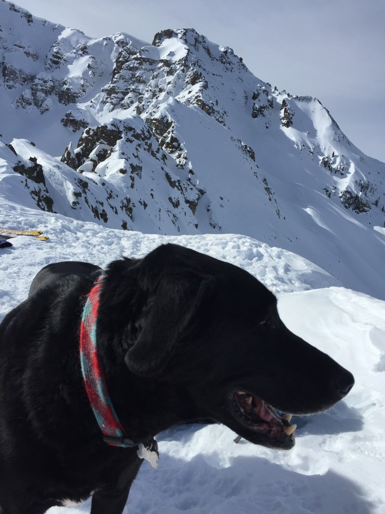
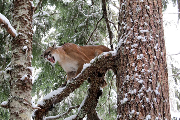
As we made our way up the trail my dog suddenly took off at a full sprint past me, with his fur standing on end. I shouted after him, but he didn’t even pause. After about five more minutes of running uphill, I caught up to him at the base of a tree. He was staring intently up into the branches.
“Silly dog, what are you doing?” I asked. Then I heard it. A low growl. I froze and followed the dog’s gaze up into the tree, terrified of what he might have treed. But the tree was empty. Only snow clung to the bare branches. Not even a squirrel or porcupine. I scanned the forest around me. Nothing. The dog quickly lost interest and trotted away to sniff a bush. But I was spooked and decided to turn around.
I ran back down, looking back over my shoulder every few seconds, until I saw a group of ice climbers heading up the trail. Then a couple of snowshoers. Then a dog-walker. Returned to civilization and the comfort of human presence, I felt silly and regretted cutting my run short.
But what about the low growl I had heard? Did it belong to some predator, just out of sight in the thick underbrush, waiting in its lair for its prey to wander by? Maybe the noise came from the crunch of my sneakers on the snow. Maybe it was the nearby babbling brook. Maybe it was just the blood pounding in my own ears. It’s likely my imagination supplies the biggest fears of all.
300 Days of Run
For the year 2016, I am going to run 300 out of 365 days.
More than two months off out of the year, you say?! That’s a less-than-lofty goal/New Year’s resolution… But think of it this way: One mandatory rest day off per week and you’re already up to 52 days. That leaves just 13 more days of not running. Just 13 days out of the whole year for being sick, getting stuck at work, nights out, being too hungover, powder days, traveling, injuries, tapering, recovering, it’s dark and cold and rainy and a million other unforeseen circumstances and excuses we come up with when searching for a reason not to get off the couch, put on the shoes and just go for a run. I’ll have to choose wisely.
Why the name? Well, it’s a play on Colorado’s supposed famous 300 Days of Sun tagline tourism marketing professionals like to use. Plus it rhymes with fun. Just like the sun claim, my project has some dubiousness about just what qualifies as “running.”
The guidelines: There’s a lot of winter in Telluride. So I’m going to count skate skiing as running. It’s aerobic, (Christ, it’s as if I’ve never exercised a day in my life every time I strap those skis on) it uses the legs (and arms) and it’s basically as good as running in my book. Hiking counts, obviously. Ski touring counts. However, lifting weights, downhill skiing/snowboarding, swimming, yoga: do not count. This is 300 Days of Run, not 300 Days of Some Kind Of Physical Activity. Except I would probably count biking — mountain, road or otherwise. I do it so infrequently that just the fact that I attempted to get back in the saddle would be so novel it should count for something. I envision 0-2 bike rides over the next year. The runs must be at least three miles or 30 minutes to count. Most of my runs are substantially more than this, but 3 or 30 is the minimum. 300 days is the maximum I feel I can do without injuring myself or sacrificing my sanity, other hobbies or social life.
Then there’s the why. After an athletic career in collegiate swimming, and after, triathlon, I moved on to long-distance trail running. I’ve completed the Tahoe Rim Trail 50k, San Juan Solstice 50-mile, 38-mile Telluride Mountain Run and the Squamish 50 mile. And I’ve finished each one. But it wasn’t pretty. I suffered. I showed up to the start line under-trained yet over-confident, in some cases sort-of injured and with the secret, shameful knowledge that I hadn’t trained my hardest. I didn’t give it my all. I wasn’t living up to my potential. And it showed. I limped across each finish line in pain, disappointed with myself, swearing off ultras FOREVER. But as much as I cursed each race, blaming my performance on the weather, the difficult course, the altitude, my nagging IT band pain, I KNEW in my heart I could have done better if only I had trained better.
So that’s what 2016 is about. No excuses. Just training. Committed. Every day. For 300 days.
I will chronicle the journey here. To keep it from devolving into a solipsistic, egomaniacal exercise for me and sheer eye-gauging boredom for the reader, I will only post about the most thought-provoking, interesting, amazing, revelatory, relatable tales and truths I learn over the next year. There may or may not be 300 of them 🙂
